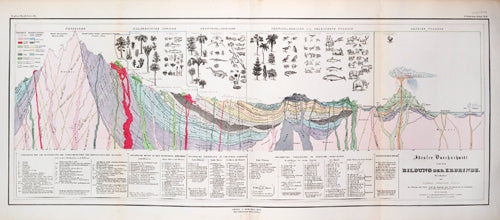
Cross-section of the Earth, showing the processes at work and animals and plants related to each geological era.
£16.00
Title: Cross-section of the Earth, showing the processes at work and animals and plants related to each geological era.
Caption: The diagram identifies rock types and the key geological processes at work in the formation of the earth. The plant and animal illustrations are allocated to different geological eras.
From: Plate '3te Abteilung, Geologie No. 11' from 'Dr. Heinrich Berghaus' Physikalischer Atlas', a two volume atlas (second edition), published by Justus Perthes, Gotha, 1852 (this plate was published in 1850).
Author: Thomas Webster.
Ref.: S0011892.
Share this item: